
The Henequen Plant
In 1984 Alice and I visited Merida for a few days while on a six week jaunt through parts of Mexico and Belize. Merida truly was the white city then. Men were wearing guayaberas and white trouser and finely woven straw hats from Becal. Women also wore white, but their dresses were heavily embroidered with brightly colored flower patterns. The city appeared to us to be clean and prosperous.
What we did not realize at that time was that we were witnessing the very end of the henequen era in the Yucatan.
In the 1950's nylon rope began to to take the place of rope made from henequen and sisal. And, by 1984, the last commercially viable crop of henequen in the Yucatan was harvested. The henequen era of enormous wealth creating plantations utilizing almost slavelike "company store" cheap labor was over. The henequen rope market collapsed, and Dupont with its new synthetic products ruled. Only narrow specialty markets survive today for these natural fibers. Those markets include paper, cloth, wall coverings, mescals for drinking and carpets,
Returning to Merida in May of 2010 we found a different city. Nikes, t-shirts (playeras) with designers names like Tommy Hilfiger and jeans are now standard dress. The traditional dress can now only be seen where it is set up for tourists.

Dress on the Plaza Grande, Merida 2010
On our trip from Merida to Belize in 1984 we took a bus and rode all day through huge henequen plantations. Today it is difficult to locate where they were as they have become overgrown - reclaimed by Mother Nature.
Henequen (Agave fourcroydes Lem.) and Sisal (Agave sisalana) are two of the many types of agave. The agave is commonly called maguey in Mexico, and there are about 208 different species. Henequen is used primarily for fiber production. Sisal is a close relative to henequen and is similarly utilized. Sisal is considered to be a "finer" fiber and is used today in some blends with cotton. I purchased a guayabera and a hamaca in Merida, and both were cotton/sisal blends.
The henequen and sisal plants appear as a rosette of sword-shaped leaves 1.2 to 1.8 meters long. They grow out of a thick stem that may reach 1.7 meters (5 ft). The leaves have regularly-spaced teeth 3-6 mm long, and a terminal spine 2-3 cm long. These sword shaped leaves are harvested in bundles and they yield the long stiff fibers that were traditionally used in making twine, rope and mattress ticking. The terms henequen (alternative spellings are henequin and heniquen) and sisal may refer either to the plant or the fiber, depending on context. Both are sometimes incorrectly referred to as sisal hemp because hemp (made from the same plant marajuana comes from) was for centuries a major source for fiber. Further confusion comes from the name of the Mexican port, Sisal, from which much of the fiber product was shipped. Henequen and sisal shipped from Sisal was labeled as from Sisal. And, often everything received from that port was commonly known as Sisal.
Although now grown in many parts of the world both henequen and sisal, are thought to be indigenous to the Yucatan.
So, while in Merida we decided to visit some of the remaining vestiges of the henequin plantations. the first was Yaxcopoil.

Fiber Processing Building Yaxcopoil

This building was a theater for plays and dances

Smokestack for processing plant
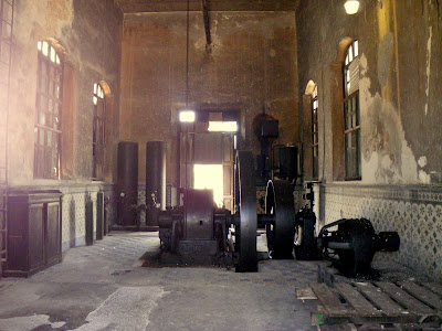 Machinery for processing


Living area, gardens and pools for owners
When we traveled to Cuzamá to visit the cenotes we were on the property of the old Hacienda Nohchakan.

Entrance to processing buildings at Hacienda Nohchakan

Processing Building

Road Marker for Hacienda Nohchakan

More Nohchakan
It is hard to grasp the great wealth that was generated from these plantations. At the height of the henequen era Merida was one of the richest cities in the world. Since the henequen collapse many of the workers from these plantations have moved into the city of Merida and since 1984 Merida has grown from around a half a million to over one million people. Merida has some industry, but is primarily dependent on tourism as its economic engine.


